
HIDDEN VALLEY
“The name “Hidden Valley” evokes a sense of mystery and discovery.”(1) Deep wooded valleys separated by steep ridges provide a diversity of habitats and a lot of terrain to discover on the 320-acre sanctuary. Nature Regina acquired this half section of land along the Qu’Appelle River Valley near Craven to preserve and interpret natural processes and ecological functions of the surrounding landscape for the benefit of members of Nature Regina and the general public.
(1) Richardson, Gillian Ed. 1992 Nature In Trust: An Account of the Regina Natural History Society 1933-1990. Regina Natural History Society, Regina
Nature Regina began to protect Hidden Valley as a Nature Sanctuary in 1945 through a lease from the Canadian Pacific Railway Company, then purchased the property in 1954 for the sum of $320 from that Company. The purpose of the Hidden Valley Sanctuary is to preserve and protect wild fauna and flora and the surface itself in a natural form. The Sanctuary is relatively small and is ecologically fragile. Visitors are welcome but we ask all visitors to respect the wildlife and the sanctuary rules.
Hidden Valley is looked after by the Hidden Valley Committee, which consists of those members who choose to be involved. One may be a member of the committee, or simply a working volunteer. The committee meets once or twice a year to discuss what needs to be done at Hidden Valley. Also, committee members and other volunteers meet for occasional work bees, depending on current needs, to do things like trail development and maintenance, fence maintenance, and invasive week management.
If you wish to learn more or be a part of the volunteer group, please complete the Volunteer Sign-Up form.
Accessing Hidden Valley
The easiest way to reach the sanctuary is to take grid 729 east from Highway 20 near Craven. Follow the grid for about 2.15 kms. until you have crossed the railway, then turn left. Follow this road along the edge of the valley for about 5.4 kms, then turn right into the Hidden Valley parking area.
If you enjoy your visit(s) to Hidden Valley we encourage you to help Nature Regina maintain this area by making a donation and becoming a member. Donations can be made at https://www.natureregina.ca/donate . If you wish to volunteer for trail maintenance or other work at Hidden Valley, please contact Nature Regina at natureregina@gmail.com .
Rules Governing Use of Hidden Valley
-
This sanctuary is first and foremost for the plants and animals that call it home. Treat the area and the wildlife with respect. Do not pick or damage the flowers, trees or other plants.
-
Access on foot only. No vehicles, no drones.
-
Visitors are free to walk any part of the sanctuary except the rehabilitation area. Years ago, a gully formed on a steep hillside due to misuse of the area. Society volunteers have successfully stopped the erosion and natural vegetation is re-establishing. This area, marked in white on the map, is closed to protect the re-establishing vegetation.
-
The wild berries growing here are important food for wildlife. The Society has therefore prohibited berry picking on the sanctuary.
-
No pets. Pets can scare and disturb the wildlife.
-
No fires.
-
No camping.
-
The area is designated as a Provincial Wildlife Refuge. Hunting and shooting are prohibited.
Exploring Hidden Valley
Hidden Valley Sanctuary is 1 mile long, from west to east and one-half mile wide, north to south. At the parking area you are near the west border of the sanctuary. While visitors are free to walk anywhere in the sanctuary, except the rehabilitation area, the society has established walking trails to aid your exploration. Trails ae outlined on the map. The Ridgeway, Valley and Woodland Trails are signed. We are developing signage for the other trails and hope to have all signed at some point during 2023. Collectively, the trails allow you to explore many of the habitats found at Hidden Valley.
Trails are maintained by volunteers. If you find a trail needs attention when you visit, consider becoming a volunteer.
Hidden Valley is a natural area. Poison Ivy is a native plant which grows at Hidden Valley and may be found adjacent to trails in some locations. We recommend you familiarize yourself with poison ivy and avoid touching it. Poison ivy is fairly easily recognized by its three leaflets and white berries. Remember the old saying, "Leaves of three, let it be."

Poison Ivy with Autumn red leaves. Note three leaves.
The Trails

1. The Ridgeway (Red on the map)
Consists of the West Ridge and East Ridge Trails, which together form a loop.
a. West Ridge Trail
From the parking area this trail takes you west, parallel to the valley road, through a shrubby area and then up the west ridge. The trail offers excellent views across the valley and many opportunities to see wildflowers on the valley slopes. It leads you onto the grasslands at the valley top where it meets the East Ridge Trail and the Valley Trail. From the junction you may return to the parking area by one of these two trails, continue to the Deer Trail, or leave the trail to walk across the grassland.
The West Ridge Trail is 0.93 km in length and climbs 74 metres.
b. East Ridge Trail
From the parking area pass through the entry gate and then immediately turn left onto the east ridge. The trail follows this ridge to the upland grasslands and junction with the West Ridge and Valley Trails. The trail is 0.69 kms long and also has 74 metres of total elevation gain. You will have great views across the Qu’Appelle and adjacent coulees and many opportunities to appreciate wildlife and wildflowers.
2. The Valley Trail (Blue on the map)
The Valley Trail provides a direct and easier route to the valley top with many opportunities to appreciate wildflowers and appreciate the scenic beauty of the Qu’Appelle Valley. Many visitors will elect to take in the Woodland Trail and then continue to the valley top. From the junction with the East and West Ridge Trails a visitor may choose to explore the grasslands off the trails or descend by one of the Ridge Trails or the Deer Trail. While the Valley Trail also gains 74 metres in altitude, it is not as steep and climbs more steadily with no dips, so involves less climbing than either the East or West Ridge Trails. The trail is 0.59 kms in length.
3. The Woodland Trail (Yellow on the map)
The Woodland Trail was designed to provide an option for people who do not wish to undertake the steep hike to the valley top and to provide visitors with a route into the Green Ash forest that covers the bottom of many of the coulees. The route initially follows the Valley Tail, then turns into the shaded forest. A bench provides an opportunity to rest in the shade at the top of the trail, watch for the forest birds and appreciate the beauty of this forest.
The Woodland Trail, including the part of the Valley Trail, has no steep climbs and 17 metres of total elevation gain. Round trip from parking lot is 0.59 kms.
4. The Saskatoon Way (Purple on map)
The Saskatoon Way, named for the abundance of saskatoon bushes along the path, allows visitors to cross the low ridge and access the coulees and ridges east of the parking area. It takes you through thick stands of saskatoons and chokecherries which are otherwise almost impenetrable. The trail gives access to the Deer Trail, Split Ridge Trail, Spurge Trail and Stone Inn Trail and opens up a part of the sanctuary which was previously rarely visited. The Saskatoon Way provides access to two routes to the valley top, the Deer Trail and the Split Ridge Trail.
To take this trail start up the East Ridge Trail, then turn left and follow the trail through shrubs and trees and over two modest ridges.
At the end of the Saskatoon Way you may turn right onto the Split Ridge Trail or keep to the left and take the Deer Trail.
The trail, from the parking lot to the Slit Ridge Trail junction, is 0.46 kms in length with an elevation gain of 12 metres, though more total climbing as the trail crosses two ridges.
5. The Split Ridge Trail (Black on map)
From the end of the Saskatoon Way the Split Ridge ascends a valley and then moves to a ridgetop, climbing to connect with the East Ridge Trail. Together the Saskatoon Way and Split Ridge provide a route to the top, one that explores some of the forested valley bottom as well as ridgetop wildflowers. From the Saskatoon Way to the junction with the East Ridge Trail, Split Ridge is 0.45 kms and ascends 65 metres. From the Saskatoon Way to the top is 0.59 kms with 70 metres total elevation gain.
6. The Deer Trail (Green on map)
Instead of following a ridge, the Deer Trail follows a coulee bottom from the end of the Saskatoon Way to the grasslands at the valley top. It is a beautiful trail, offering an opportunity to appreciate the forest, shrubs and understory vegetation as well as the birds of the forest. This trail is 0.61 kms long and ascends 75 metres from the end of the Saskatoon Way. The Deer Trail also provides access to the Stone Inn Trail and the Spurge Trail.
7. Stone Inn Trail (Light blue on map)
This trail follows near the border of our property taking you through forest and a couple low ridges. The trail does connect to the adjacent yard (The stone Inn), allowing the residents access to the trails. The Stone Inn is private property, not party of our sanctuary. Please remain on Hidden Valley property and do not wander into the yard. The Stone Inn Trail is 0.4 kms in length with an elevation gain of 16 metres.
8. Spurge Trail (Pink on map)
This trail runs between the Stone Inn Trail and the Deer Trail, providing an opportunity to do a very interesting hike without the full climb to the valley top, traversing a mix of forest and grassland. Alternately, it provides a alternate route and longer route to the top via the Deer Trail. The Spurge Trail is named for a patch of leafy spurge, an invasive weed, discovered along the trail, one of the advantages of having easier access to this part of the sanctuary. Nature Regina released beetles in this patch as a biological control in 2022. A follow up visit showed the beetles apparently doing well. We hope they will prosper and reduce the amount of leafy spurge. The Spurge Trail is 0.33 kms in length with an elevation gain of 30 metres.
9. Ridge Top Footpath
The Ridge Top Footpath is not a formally maintained trail, but there is usually a path made by deer and hikers which follows the ridge top to the edge of our property with some great views over coulees and the Qu’Appelle Valley. This is also the most popular route for exploring the prairie grasslands and provides access from the Ridgeway to the Deer Trail.
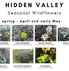
Wildflowers
One of the many joys of hiking at Hidden Valley is the many wildflowers that can be seen as well as the butterflies, bees and other insects visiting the wildflowers. To assist visitors, we have listed some of the more commonly observed wildflowers by season. You can see photos of some of these wildflowers on this website. We also recommend the Saskatchewan Wildflowers website maintained by society member Glen Lee as an excellent resource to help you identify Saskatchewan wildflowers.
Supporters
Nature Regina gratefully acknowledges the ongoing support of the R.M. of Lumsden, which, in support of our conservation objectives, has exempted the property from taxation.
Nature Regina would like to thank EcoFriendly Sask for their grants in 2015 and 2017 to improve signage at the sanctuary.